What should I do?
Go to the online evacuation map or download the map by using the buttons below. Determine which care center you would go and how to get there.
If an evacuation begins, don't panic and don't rush. You will have plenty of time. When you leave home, please affix a sign to the front of your home so officials will know you have been notified and have evacuated. Click here to download a sample sign. If you do not have a printer to print the sample sign, please create a similar sign and affix it to your front door.
As you leave the area, tell a neighbor about the evacuation. He/she may not know about the emergency or may need a ride to a reception center. You may need to stay at the center for two (2) or three (3) days. This will depend on conditions at the plant.
Emergency supplies
- Change of clothing
- Baby supplies
- Blankets and pillows
- Flashlight and batteries
- Portable radio
- Medications
- Soap and shaving equipment
- Eyeglasses
- Health insurance information
- Checkbook/credit cards
- Towels and washcloths
- Sanitary supplies
- Personal identification
What about sheltering?
Sheltering means to stay indoors. Close all doors and windows. Turn off sources of outside air. Close the fireplace flue if not in use. Remain indoors until told it is safe to go out. Use the telephone only for medical, fire, or other extreme emergencies! If traveling in a vehicle, close windows, air vents, and put the air conditioner on the maximum setting if needed.
Always listen to your local radio station or Tone Alert radio for further instructions.
What about staying indoors?
Staying indoors is very similar to sheltering. However, there are some important differences. Because the mid-summer heat in Arkansas can often climb well above 100 degrees, closing off your home without air conditioning could present more of a health hazard than the one presented in a release at ANO. Therefore, staying indoors refers to just that, staying indoors but with your air conditioning or heat running to keep you cool in the summer or warm on a cold January day. The filters in your home’s heat and air system will also act to filter some of the radioactive particulates that might be in the air in your area because of a release at the nuclear plant. The Department of Health believes this to be a logical and safe alternative to sheltering during weather extremes such as heat or snow and ice.
IDrive Arkansas
IDrive Arkansas will show you the location of each construction zone on the state highway system. Activate the live traffic / traffic camera features for a clear understanding of how traffic is moving up to and through each construction zone. Add the weather radar feature and determine the impact storms are having on traffic moving through construction zones. https://idrivearkansas.com/
Evacuation route signs
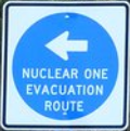
Signs marking designated evacuation routes are in place along state highways. These indicate the direction to the Designated Reception Centers where you should report in the event of an evacuation resulting from an emergency involving Arkansas Nuclear One.
Family preparedness
Your family may not be together when an emergency occurs, so it is important to have a family plan. Your plan should include how you will contact each other if you are separated during an emergency. For example, have each family member contact other family members who live outside the Emergency Planning Zone (EPZ). Everyone must know the name, address, and phone number of the contact. You may have trouble getting through, so be patient.
Have two predetermined locations outside the Emergency Planning Zone (EPZ) where your family can reunite, if separated.
For additional planning information, you may refer to www.ready.gov.
What about my pets?
For reasons of health and safety, it is strongly recommended that pets not be brought to any reception center, however, it may be necessary under certain circumstances to do so. To facilitate the reasonable accommodation of domesticated animals, measures designed to assure a safe stay at the center are required. Domesticated pets are defined as dogs, cats, birds, rabbits, rodents or turtles or animals traditionally kept in the home for pleasure rather than for commercial purposes and can travel in commercial carriers, and be housed in temporary facilities. Reptiles (except turtles), livestock and animals classified as "vicious animals" will not be accepted.
While pets will not be allowed inside the actual reception center, limited facilities will be provided for the housing of your domesticated animals nearby. Animals should be transported in and remain housed in, portable containment devices while at the reception center pet facility. Care of these animals, such as providing food and water, will be the responsibility of the owner. Veterinary care needed by individual animals will have to be provided by the pet's owner. Liability for any harm or damage caused by the animal while at the reception center facility will also be the responsibility of the owner. Also, bringing your pets to the reception center will delay your entry to and processing from the reception center. It is believed that pets would not be put in any danger should they be left behind, especially if pet owners have areas in which they can house their pets, such as an enclosed garage. Whatever radiation to which they might be exposed is not believed to be great enough to cause any physical harm to them. Also, the lower radiation levels that would be expected to be emitted from an accident at ANO might take many years to manifest into any health problems and since most pets do not have a life expectancy exceeding this time frame, the likelihood of them suffering from an illness brought upon them by exposure to radiation from a possible release from ANO is remote. The shock and turmoil of uprooting these animals from their normal surroundings might actually prove more harmful to them.
'Service animals' will be accepted at all Reception Centers; however, the owners will be responsible for care and control.
Radiological information for farmers and gardeners
This information was prepared to answer questions that farmers and gardeners might have after a serious accident at Arkansas Nuclear One.
Radioactive material might be released from the nuclear plant to the environment during a serious accident. It could fall onto soil, grass, or surface water, and then be taken into the food chain by plants and animals.
To protect dairy animals, use uncontaminated water and feed supplies. Move dairy animals off pastures and into dry feed lots.
Safe water will be the most important need for animals--even more important than feed. Since you may be away from the livestock for at least 48 hours, provide a 48 hour emergency water supply in livestock shelter areas.
Protect other water supplies from contamination. Cover stock tanks with plastic sheeting or canvas. Water in an open pond would be contaminated and should not be used until shown to be safe. Feed stored in sheds or silos or under a canvas or plastic cover should be used instead of letting animals graze. Feed stored outside, such as hay, that cannot be covered in time can still be used if outer layers are removed.
Suspected contamination would mean that produce must be checked before consumed. In most cases, garden foods may be cleaned by a thorough washing with water. Roots and tubers are not affected by surface contamination.
If you have been instructed to evacuate your farm, you may be allowed to return to feed and care for your livestock. Permission to return to evacuated areas must be obtained through your County Emergency Operations Center and the State Technical Operations Control Director. More information is available from your County Agent's Disaster Handbook for Extension Agents, published by the United States Department of Agriculture or by calling the Arkansas Department of Health at 1-800-422- 6630 (toll-free) or (479)968-7171. TDD users may call 858-7890 or 1-800-633-6413 or 711 after normal hours.
Zones and Reception Centers
NOTE: Personnel will be in place at each reception center host city to direct evacuees to their designated reception centers.
ZONE "G"
Zone Description: The area within approximately two miles of Arkansas Nuclear One. This includes Lake Dardanelle, the ANO peninsula, Mill Creek, 40 Acre Rock and London Communities.
Reception Center: Residents of this zone should proceed to the designated reception center at Hector High School.
Evacuation Routes: Persons living in Zone G should take Highway 64 or Highway 333 to Highway 7, then Highway 7 to Dover, then Highway 27 to Hector.
ZONE "H"
Zone Description: Russellville residents west of Arkansas Avenue and south of Interstate-40. This includes Norristown and the Dardanelle State Park area.
Reception Center: Residents in this zone should proceed to the designated reception center at Morrilton Junior High School.
Evacuation Routes: Persons living in Zone H should take Interstate-40 or Highway 64 east to Morrilton or Highway 247 to Highway 64 then east to Morrilton.
ZONE "I"
Zone Description: Russellville residents south of Interstate-40 and east of Arkansas Avenue. This includes the South New Hope Community.
Reception Center: Residents in this zone should proceed to the designated reception center at Morrilton Junior High School.
Evacuation Routes: Persons living in Zone I should take Interstate-40 or Highway 64 east to Morrilton or Highway 247 to Highway 64 then east to Morrilton.
ZONE "J"
Zone Description: Pope County residents north of Interstate-40, south of Bakers Creek and east of the Illinois Bayou.
Reception Center: Residents in this zone should proceed to the designated reception center at Morrilton Junior High School.
Evacuation Routes: Persons living in Zone J take Interstate-40 or Highway 64 east to Morrilton, or Highway 124 to Highway 326 East to Highway 105 to Atkins, then east on Interstate-40 or Highway 64 to Morrilton.
ZONE "K"
Zone Description: Pope County residents north of Highway 64, west of the Illinois Bayou, east and south of Highway 333, and south of county road 79(also known as Shinn Mountain Road) and county road 141(also known as Lower Shinn Mountain Road).
Reception Center: Residents in this zone should proceed to the designated reception center at Hector High School.
Evacuation Routes: Persons living in Zone K should take Interstate-40, Highway 333 or Pleasant View Road to Highway 7 then Highway 7 to Dover, then Highway 27 to Hector.
ZONE "L"
Zone Description: Pope County residents east of the Illinois Bayou and north of Bakers Creek. This includes Dover and the Linker Mountain Community.
Reception Center: Residents in this zone should proceed to the designated reception center at Hector High School.
Evacuation Routes: Persons living in Zone L should take Highway 7 to Dover then Highway 27 to Hector, or Highway 164 to Highway 105 then take Highway 27 north to Hector.
ZONE "M"
Zone Description: Pope County residents north of Hickeytown Road, east of Highway 333 and north of county road 79(also known as Shinn Mountain Road) and county road 141(also known as Lower Shinn Mountain Road). This includes the Augsburg, Rushing and North New Hope Communities.
Reception Center: Residents in this zone should proceed to the designated reception center at Hector High School.
Evacuation Routes: Persons living in Zone M should take Highway 333 to Highway 7 to Dover, then Highway 27 to Hector.
ZONE "N"
Zone Description: Pope County residents south of Hickeytown Road, west of Highway 333 and north of Lake Dardanelle.
Reception Center: Residents in this zone should proceed to the designated reception center at Hector High School.
Evacuation Routes: Persons living in Zone N should take Highway 333 to Highway 7 to Dover then Highway 27 to Hector.
ZONE "O"
Zone Description: Johnson County residents east of Highway 359 and south of Flat Rock Creek.
Reception Center: Residents in this zone should proceed to the designated reception center at Clarksville High School.
Evacuation Routes: Persons living in Zone O should take Highway 64, Interstate-40 or take Highway 359 to Highway 64 west to Clarksville.
ZONE "P"
Zone Description: Johnson County residents north of Flat Rock Creek and west of Highway 359. This includes the Piney, Piney Bay, Knoxville and Hickeytown Communities.
Reception Center: Residents in this zone should proceed to the designated reception center at Clarksville High School.
Evacuation Routes: Persons living in Zone P should take Highway 64, Interstate-40 or Highway 359 to Highway 64 west to Clarksville.
ZONE "Q"
Zone Description: Logan County residents residing between Delaware and New Blaine. This includes the New Liberty, West River Mountain and Nichols Lane area.
Reception Center: Residents in this zone should proceed to the designated reception center at Paris High School.
Evacuation Routes: Persons living in Zone Q should take Highway 22 west to Paris.
ZONE "R"
Zone Description: Logan County residents within an area approximately two miles west of the Logan - Yell county line. This includes Wildcat Hollow, Delaware, Delaware Lake Area, River Mountain Road east of Flurry Road and Highway 22 east of Johnson Lane.
Reception Center: Residents in this zone should proceed to the designated reception center at Paris High School.
Evacuation Routes: Persons living in Zone R should take Highway 22 west to Paris.
ZONE "S"
Zone Description: Yell County residents south of Mt. Nebo Road and west of the Dardanelle city limits. This includes the Slo Fork and Sulphur Springs areas.
Reception Center: Residents in this zone should proceed to the designated reception center at Danville High School.
Evacuation Routes: Persons living in Zone S should take Highway 27 to Danville or Highway 7 to Ola, then Highway 10 west to Danville; or Highway 28 to Mt. George, then Highway 154 to Highway 27 to Danville.
ZONE "T"
Zone Description: All residents of the city of Dardanelle.
Reception Center: Residents in this zone should proceed to the designated reception center at Danville High School.
Evacuation Routes: Persons living in Zone T should take Highway 7 south to Ola, then Highway 10 west to Danville.
ZONE "U"
Zone Description: Yell County residents north of Mt. Nebo Road and west of the Dardanelle City limits. This includes Mt. Nebo, Haney Hollow, Wildcat Hollow in Yell County and the Lake Dardanelle State Park area.
Reception Center: Residents in this zone should proceed to the designated reception center at Danville High School.
Evacuation Routes: Persons living in Zone U should take Highway 22 or Highway 155 east to Highway 27, then Highway 27 to Danville.
NOTE: Personnel will be in place at each reception center host city to direct evacuees to their designated reception centers.